.
.
The Route
Distance options: 43, 56, 69, 82, 99 and 126 miles.
Full route has six good climbs, shortest route has three.
 |
|---|
| 6686 ft of climbing (and descending) |
|---|
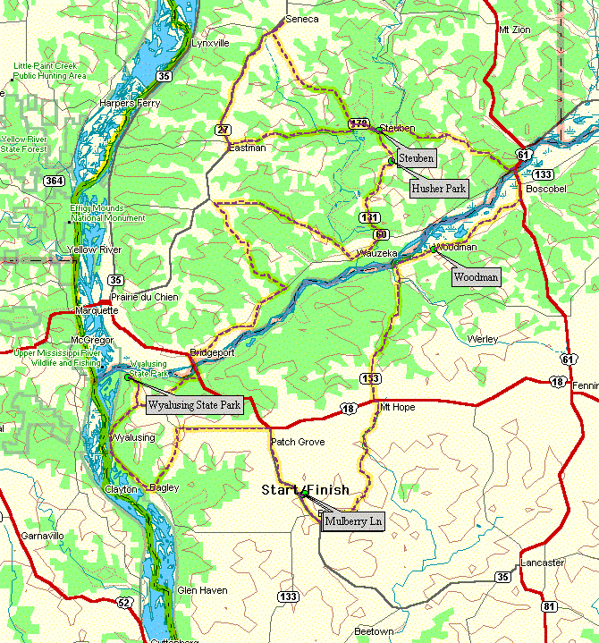 |
|---|
| Route Map! |
|---|
Words from the immortal J.K. Anderson:
	This year's Suicide Century will be a little different than
last year.  We will still be starting and finishing at the home of
my mommy just outside Bloomington, WI, and we'll still get a good sampling
of some of Wisconsin's more scenic riverways, including the Wisconsin
and Mississippi.  This year we've added a stretch that takes us in and
out of the Kickapoo River valley, quite scenic as well.
This ride also offers a couple of shorter options, so those not so
interested in riding over 100 miles can still come out and enjoy the
weather.  And not that it really matters, but SC'00 takes us right through
the heart of JKA's old stomping grounds.  On the full version of the
ride, you'll get to enjoy downtown Steuben, a glance of Eastman,
Wauzeka (where I attended school, K-12, same building), Bush Field,
the Horseshoe Tavern, and the Burt O. Anderson homestead/reforestation
project.

     Along with the nostalgia that only I can truly appreciate, everyone
should be in for some great scenery, nice parks, small town hospitality,
and a challenging bike ride.  Here's the route:

We'll leave from Mom's house and head up Mulberry Lane to Hwy 35.
Left on 35 and head south into Bloomington.
Left on Cty A, head north to Cty J.
Left on Cty J, north to US Hwy 18.
Left on 18, head west ~1/8 mile to 133.
Right on 133, head north to Woodman--
Possible rest stop at Woodman boat landing
Continue on 133 into Boscobel, to US Hwy 61
Left on 61, head north through Boscobel, across the brand new
bridge to 60. (I formally requested that the state replace the steel
grid with something a little more bicycle friendly.  Hope they're
done by August...  wading across the Wisconsin River isn't as easy
as last year's stream)
Anyway, left on 60 for about 1/8 mile to Cty E
Take a right on Cty E, up and over the ridge to 131.
Left on 131, head south into Steuben.

Once you're in Steuben, its time to choose.  The official century
route makes a loop that begins and ends in Steuben, then continues
south on 131.  To cut ~26 miles off the ride, you can just head
straight through Steuben on 131.  (But no one ever wants to head
straight through Steuben without stopping to enjoy; no words can
do it justice.)

Century:  Head west out of Steuben on 179 to where Cty E splits off.
       Take a right on Cty E, head northwest to Seneca.
       From Seneca, take a left onto 27, and head south to Eastman.
       Just at the outskirts of downtown Eastman, turn left on 179.
       (Feel free to venture into town, Eastman is another good one;
       the primary industry is selling beer to softball players.)
       Head east on 179, back to Steuben.

Right on 131, and head south toward Wauzeka.
About 5 miles out of town at the tiptop of the ridge, there is
a wayside on the left called Husher Park.  This is an official rest
stop and end point for two of the length options.
There is no shame in stopping here... you'll know you just finished
a 43 mile ride (69 miles with the Steuben loop).
Shuttle service is then provided to Wyalusing State Park for a
leisurely afternoon, and then home.  If you want to lengthen the
route to about 56 miles (82 with Steuben loop), you can ride the
last 13 miles from Wyalusing to home.

Riding on from Husher Park, you continue south on 131 to 60.
Right on 60, head west into Wauzeka.
      By this point, after Bloomington, Steuben, Seneca, Eastman,
and Steuben again, you'll be astounded by the sheer magnitude of the
village of Wauzeka. You'll get to take in most of town as we head
right through on the main drag... but not to worry, you won't have
to click your feet out of those pedals because there isn't a stop
sign on Main Street.

As you make your way through the near west suburbs of Wauzeka,
take a right on Cty N and head north out of town.
First thing you encounter is Cemetery Hill which used to kick my
butt as a youngster-- it'll probably do it again this August.
Stay on Cty N for about 8 miles, to Dutch Ridge Road.
Take a left on Dutch Ridge Road, and head southeast about 3 miles to
Bush Hollow.
Right on Bush Hollow, and south back to 60.
On your way down Bush Hollow
you'll ride right past Bush Field, home of the Bush League on the banks of
beautiful Bush Creek.  It hasn't been maintained for a few
seasons, but years ago there were some real players that used that field.

Anyway, right on 60 and head to Bridgeport.  (The Horseshoe Tavern is
on your left only a couple of miles up the road, 6 miles from the
nearest town, but just 600 short yards away from my dad's place where
I spent my younger days.  Check out the trees as you ride by.)

In Bridgeport, take a left on 35 and head south back across the
Wisconsin River.  After the bridge, take a right on good old Cty C,
and head west.
Our favorite bridge from last year is finished, so you can take a
running start at the hill.

Take a right on Cty X and about a mile later, another right into
Wyalusing state park.  (No south picnic grounds this year-- we'll stick to
the more conventional sites.  Of course, if you're so inclined, no one is
going to discourage you from riding to the south picnic area.)
Enjoy the view of the confluence of the Wisconsin and Mississippi,
a nice refreshing snack, and the satisfaction of knowing you've made it up
all the big hills.  The 13 mile home stretch is pretty smooth sailing.

Note:  although we will have the support vehicles at the park, this is not
an official stopping point.  If there is some unforeseeable valid reason to
stop here (major mechanical failure or medical emergency), catching the
sag wagon home wouldn't even be an inconvenience.  However, for any reasons
short of the two listed above (like "I'm tired" or "my butt hurts"), there
is much, much shame in stopping here.

Out of Wyalusing take a left, and head back on Cty X to Cty P.
Left on Cty P, and head west to Hwy 35.
Take a right on 35, go about 1/4 mile and turn right on 133.
Head south on 133 through Patch Grove, and about 3 miles outside
of town, left on Mulberry Lane.
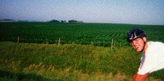
Some Pictures from 1999
 |
|---|
| Don Holly crests Cty Hwy C. |
|---|
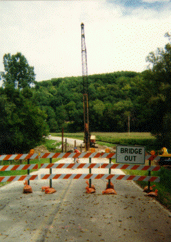 |
|---|
| Bridge out? |
|---|
 |
|---|
| No problem. |
|---|
 |
|---|
| The gang at Wyalusing rest stop. |
|---|
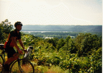 |
|---|
| Chris above the Mississippi River. |
|---|
 |
|---|
| Christina and Pat: driving support. |
|---|
 |
|---|
| Chris, John, and Jay sporting the shirt |
|---|
 |
|---|
| The Back of The Shirt |
|---|
Ted Biewer (biewer@loki.physics.wisc.edu)